Yesterday I had so much fun while riding with my sister and brother in law, that I decided after breakfast I'd go visit more of the island, and as I was forced to point the bike and it's near empty tank east towards Cornwall and Charlottetown, a consultation with the breakfast crew plotted me a trip out to Prim Point, and Beach Point Harbour with plans later on to visit Panmure Island, but I stopped to take too many pictures and to be honest, I was a bit worried about being caught out after dark when the temperature drops.
 |
| Stanchel PE to Murray Harbour PE |
On the way to breakfast on South Melville road, is a lovely view down towards De Sable that I've ignored a few times as it's close to a beautiful chicane, and I just never bothered. You can make out the ocean, just a splash of blue in the centre.
 |
| Looking towards DeSable |
 |
| Near Bonshaw along the TCH |
 |
| Same again, the opposite side of the TCH looking south. |
 |
| The view from Pownal Road Route 26 |
 |
| It's not so bad when it's oncoming in a double lane, but try passing this on a back road and you 're suddenly glad you're on a dual sport. |
 |
| At the head of Dykerman road, there are realtor signs advertising building lots with this as the view at the foot of the road. |
 |
| Near Vernon Bridge along the TCH |
 |
| The cows are enjoying the views along the Seal River too. |
 |
| They spray the tops of the potatoes to kill off the foliage before the harvest. |
 |
| On the left is the harvester, on the right is the sprayer |
 |
| This house has a commanding view of the following photos. Simply stunning. I wonder if it's for sale? |
 |
| My sister thought these might be rose hips. |
 |
| Soy Bean spill!!! Don't try to brake hard on a damp clay road covered with soy beans. |
 |
| Obstacle! Easy to get round him though... |
 |
| Point Prim road |
 |
| Birds on a wire |
 |
| I made it this far... |
 |
| It's a dark shot, but the only one that presented itself at the time. I'll take it. |
 |
| Point Prim Lighthouse |
 |
| Sea gulls where they are supposed to be for once. |
 |
| Well, perhaps not as dangerous as riding a bike. The earth gets undercut, so you should really only trust visible rock. The breakwater here is imported granite and some cement shoring as well. |
 |
| Soy crops along the point. |
So I navigate many of my rides with an older Garmin 60cx GPS, and it likes to tell me to stick to the main roads, so I do my best to mess it up and think, otherwise I'd miss "No Exit" shots like these at the foot of MacAulays Wharf Road:
 |
| The view from MacAulays Wharf |
 |
| Back on the TCH. Can you make out the bird in flight here? I think it doesn't care for motorcycles. |
 |
| Before the TCH this might have been the way to get to the other side of the river. |
The GPS showed I was close to a large sand bar, and I wanted to get a closer look at it, so took the next marked road that went south, but roads on the GPS look more like farmers access roads, especially when grass is growing up between the tire tracks...
 |
| My bike in the Northhumberland Strait. |
 |
| Don't get used to the Ontario plates, as I need to get PEI plates before my birthday. |
Those were taken at the foot of Gascoigne Road off of the TCH, but don't take your house trailer down that road, or your Harley.
 |
| The view from Shore Road 4 near Wood Islands Ferry |
 |
| I'll call this the Cape Bear lighthouse. This is the kind of thing you're used to seeing in PEI postcards no doubt. |
 |
| It's the coasline like this that enthralls me, for you don't see much of it where I grew up. |
 |
| Happy Thanksgiving! This one needs a bit of time yet. |
 |
| For my sister. |
I just want Wendy to know that in the process of getting this shot, or rather getting my bike back on the road, I dumped it in the ditch by the roadside. A combination of wet ground and my feet dangling over nothing, and over she went. Lol.
 |
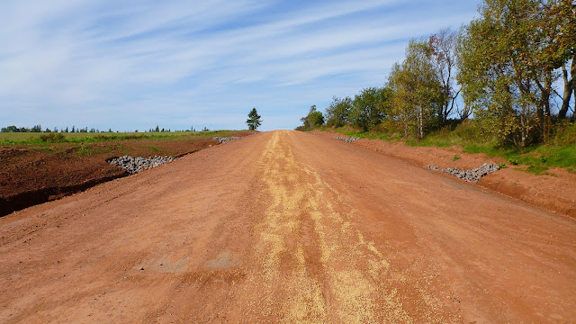
| This just past the lighthouse on 18, now a dirt road call Black Brook Road. |
The bulk of the red earth shots are all taken at Black Brook Road just off of Cape Bear Road 18 past the lighthouse.
 |
| Looking towards Beach Point from the cape. |
 |
| This is close enough I think. |
 |
| Yep. Undercut by wind, water and runoff. One day this sign will fall into the Ocean. |
 |
| Ah! If only I'd been here in the morning instead of afternoon! |
 |
| I think I need to visit this again when the lighting changes. |
 |
| Here you go, Beach Point Wharf |
 |
| And I'll leave you with this view from Beach Point beach. :D |
So all this took from 1100 to approximately 1530 when I fuelled up in Murray River and made a beeline back to Charlottetown and Tim Horton's where I ran into the Harley crowd out for a thanksgiving ride. Pumpkin spice muffins are a great post ride treat. :D
Oh, the temperature did drop about three degrees as the shadows grew longer and some dense cloud cover rolled in over the Summerside. :P


No comments:
Post a Comment